Earthbound Artist

Articles tagged as Kayaking (view all)

Killarney Shores: Through an Artist's Eye

19 June, 2025 3 comments Leave a comment

Killarney Provincial Park was established on the north shore of Georgian Bay in 1964, but its origins trace back to the conservation efforts of artists, notably A.Y. Jackson of the Group of Seven, who pushed to protect the area for wilderness recreation and its unique landscape. 

For several decades, I have heard of the natural wonders of this region, and this spring spent a week camping, hiking, and kayaking there, camera in hand. It was a dream come true.

In this post, I am sharing photos from four distinct locations in the Killarney area.

POINT GRONDINE PARK:

We set up camp in Point Grondine Park, a First Nation owned and operated 18,000 acre recreational area east of Killarney Provincial Park. 

Point Grondine Park features 12 new spacious campsites for tent or trailer camping.  They are primitive in nature (which means they are off grid, with privy toilets available on site) but very private and quiet. It was so lovely to wake up each morning surrounded by trees and birdsong.

Our Airstream trailer provided all the comforts of home - propane powered refrigerator, stove and oven; flush toilet and shower; comfortable queen-sized bed; and solar powered batteries for our satellite internet. We used our gasoline-powered portable generator a few times for additional electrical needs.

One day we hiked to Mahzenazing Lake, which had some lovely rock outcroppings along its shoreline. This is the largest interior lake in Point Grondine Park.

Scenes of fresh water, sturdy smooth rocks, and wind-sculpted trees, (very typical elements of the Canadian Shield), always captivate my artistic mind. I was able to capture several paint-worthy views with my camera during our hike.

KILLARNEY LIGHTHOUSE TRAIL:

Another day we drove to the little town of Killarney on the shore of Georgian Bay to hike the famous Lighthouse Trail (pictured below).

The slabs of rock were huge, and we spent an hour clambering along the shore. I love the powerful diagonal lines of rock crevices, and the blue/orange colour palette in the photo above.

Shown above is another dramatic photo from that day, featuring interesting puddle shapes that lead the eye toward moody skies over Georgian Bay. This will translate into an awesome painting.

Interesting lichens provided a striking colour contrast with pink granite, worn smooth over millions of years. The Canadian Shield is very old, with parts of it dating back over 4 billion years. This makes it one of the oldest and most stable geological regions on the planet. 

CHIKANISHING TRAIL IN KILLARNEY PROVINCIAL PARK:

My favourite hike of the week took us 3 km along the Chikanishing (pronounced chicken-ISH-ing) Trail in Killarney Provincial Park. We hiked over several large smooth granite ridges with beautiful old growth pines, pictured above. The patterns of lichens were extraordinary, especially when you realize these plants only grow about 1 mm in diameter each year.

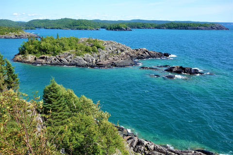
We soon reached Georgian Bay, where a collection of rocky islands dotted the shoreline. I was delighted to see two kayakers paddle by, to provide a sense of scale and adventure in the photo above.

Everywhere I looked, pink granite provided a stunning contrast to blue water and sky, and pale green lichen added its unique textural topping to the rocks.

The water of Georgian Bay was very clear, revealing underwater stones and rock shelves. I always wonder how large trees can anchor and survive on what appears to be solid rock on these islands.

Shown above is another dramatic composition with diagonal lines and my favourite blue/orange colour combination. Intricate lichens add interest to the foreground.

As we sat on a rock ledge eating our picnic lunch, it seemed there was a potential painting subject everywhere I turned. 

While we paused to absorb the beauty and peace of these rocky islands, I was reminded anew how fortunate we are to live in this part of the world. 

GEORGE LAKE IN KILLARNEY PROVINCIAL PARK:

On our last day of camping in Killarney, the weather was warm and sunny with little wind, so we took the opportunity to launch our kayaks from the beach at George Lake in Killarney Provincial Park. The photo above shows me in my kayak at the base of one of the impressive rock cliffs on the lake.

Shown above is the same rock face from a different angle. My kayak would look like a tiny speck in this photo.

Shown above is one of the most famous rock cliffs on George Lake. I love the diagonal rock crevices juxtaposed with vertical mineral stains. The two pines at the summit give a sense of scale to this massive, smooth headland.

The same headland looks very different viewed from behind (pictured above). That smoothly eroded kind of rock surface always reminds me of elephant hide.

George Lake is lined with interesting rocky shores. The contrast of pink granite and green conifers dominates the photo above.

Our day on the water provided a fitting finale to our week exploring the wonders of Killarney. Now I understand why artists like the Group of Seven were captivated by this stunning region and kept returning here to capture the iconic Canadian Shield landscape in their famous paintings. I have so much admiration for this land and look forward to capturing some magic of my own in watercolour. Stay tuned!

If you have comments you wish to share, please do so using the 'Leave a Comment' button at the top of this post.

Subscribe to Karen's Newsletter for exclusive early access to new work, studio news updates, travel tales, painting tips, and notices of upcoming exhibitions.

Lake Superior Perfection: Top 10 Pukaskwa Views

01 November, 2021 4 comments Leave a comment

Pukaskwa National Park, photo by Karen RichardsonThis past August, as my husband and I explored the north shore of Lake Superior with our travel trailer in tow, we had the immense good fortune to obtain a serviced camping site for a week in a most amazing place that very few people have heard about: Pukaskwa National Park.

Pukaskwa National Park, photo by Karen Richardson Over the years, we had seen the sign for the turnoff to this Park on Hwy 17 between Wawa and Marathon and finally dropped in for a few hours in the summer of 2020, to check out the camping facilities.

We were so impressed by that short glimpse of the Park that we made plans to camp there this year.

Pukaskwa (pronounced PUCK-a-saw) has been a National Park for over 40 years and covers an area of 1,878 square kilometres (725 sq mi), protecting part of the longest undeveloped shoreline anywhere on the Great Lakes.

There are four large natural sand driftwood beaches in the Park, three of which are pictured here. (That is my husband John walking on a typically uncrowded beach.)

Pukaskwa National Park, photo by Karen Richardson

Our stay coincided with a week of hot, dry weather due to a tropical storm in the Gulf of Mexico pushing a warm front up our way.

Even though summer high temperatures along the shore usually max out at 15 C (59 F), we enjoyed a whole week of daytime highs of 24 C (75 F) and mild nights. There were no mosquitoes or black flies, but lots of birds and butterflies.

It was a glorious week; we swam, strolled the beaches, went for hikes, paddled in our kayaks, ate alfresco meals at our campsite, and generally enjoyed being out in nature in perfect conditions.

Pukaskwa National Park, photo by Karen Richardson

There were four easy to moderate hiking trails surrounding the campground, all less than 4 km (2.5 miles) in length. A few of them took us high above the lake to viewpoints that offered stunning vistas such as those shown here. The trails were so awe-inspiring that we hiked them more than once.

The water is very clear, and the white sand bottom gives the water a turquoise appearance similar to Caribbean or Mediterranean waters. But the wonderful thing is, Lake Superior holds fresh water, not salt, so there was nothing to bite, sting, or eat us while we swam!

Pukaskwa National Park, photo by Karen Richardson

This lake is so vast, you think you are looking at the ocean when there is only water as far as you can see. It is the largest body of fresh water on earth, with a surface area of over 82,000 square km (31,660 square miles), and over 4,000 km (2,500 miles) of shoreline.

Karen Richardson at Pukaskwa National Park

We spent a lovely afternoon in our kayaks exploring the protected bay of Hattie Cove. (Our kayaks are too short to withstand the waves out past the islands.)

Pukaskwa National Park, photo by Karen Richardson

These photos show us with massive rock cliffs in the background. The bay was shallow and featured many interesting islands of varying sizes and shapes.

There is something about islands, even tiny ones, that always captures my attention. I'm certain the ones shown in this post will be featured in my paintings some day. 

Speaking of paintings, I wrote an article about my first six paintings inspired by Pukaskwa. Check out New Works: Nights on Fire.

Pukaskwa National Park, photo by Karen Richardson

Pukaskwa National Park, photo by Karen Richardson

To sum up our week-long experience, I think the Park pamphlet says it best:

Pukaskwa National Park, photo by Karen Richardson

"Pukaskwa National Park is a vast, wild, natural playground found on the edge of the world's largest freshwater lake. It's a place where powerful waves collide with rugged, towering coastlines; a place of endless sunsets over sandy driftwood beaches...A place where Lake Superior's untouched beauty can be seen, experienced and remembered by all who visit."

I agree wholeheartedly.

As in all National Parks, Pukaskwa has a pair of those iconic red Muskoka chairs installed, overlooking picturesque Pulpwood Harbour. What a lovely spot this was to rest after a day spent clambering over these magnificent rocks. 

I have a treasure trove of photos from our time in Pukaskwa, ready to inspire more new paintings. Stay tuned!

If you have comments you wish to share, please do so using the 'Leave a Comment' button at the top of this post.

Subscribe to Karen's Newsletter for exclusive early access to new work, studio news updates, travel tales, painting tips, and notices of upcoming exhibitions.

Exploring Lake Superior - At Last

30 September, 2017 4 comments Leave a comment

Rossport Islands in Lake Superior

Over the years, our travels on the trans-Canada highway have taken us past the north shore of Lake Superior countless times. We always seemed to be in a hurry to get out to the western provinces to visit family, or to return to our home in central Ontario. We never took the time to stay in this wild and beautiful region of northern Ontario.

This summer, we finally planned a two-week camping trip to explore Rossport and Wawa on Lake Superior. The Lake Superior view above is from Nicol Island at Rossport.

Karen Richardson kayaking on Brownlee Lake, east of Lake Superior, Ontario

On the way there, we enjoyed several days in a private campground on Brownlee Lake (east of Lake Superior), which we were able to explore fully by kayak. That's me in the photo above.

Waterlily leaves and reflections on Brownlee Lake, Ontario

Water Lily on Brownlee Lake, Ontario

The leaves of the waterlily plants had started to change colour when we were there in August. These photos will make great painting subjects.

Mushroom on the shore of Brownlee Lake, Ontario

As we explored the perimeter of Brownlee Lake, we found many colourful mushrooms had recently emerged. This one reminds me of a fairy toadstool.

Karen Richardson in Rainbow Falls Provincial Park

High Falls, near Wawa, Ontario

Our hikes in the region took us to many scenic waterfalls. I am pictured above in Rainbow Falls Provincial Park, east of Rossport. The second photo is High Falls, which is accessible via a commercial wild blueberry farm near Wawa.

Rock point, Rainbow Falls Provincial Park at Rossport.

The most scenic part of our holiday was spent at Rainbow Falls Provincial Park (Rossport), which has a campground right beside the beach. The park's rocky point pictured above is the subject of a sold-out watercolour workshop I am teaching in my Lindsay studio this fall.

Rossport Coastal Trail, Lake Superior

The view above is from the Rossport Coastal Trail on Lake Superior. The water is very cold and clear, so you can see the colourful stones on the lake bed. I am working on a stunning new painting, inspired by this scene.

Karen Richardson's travelling and camping rig

The photo above shows our truck, trailer, kayaks, and dining tent set up in Rainbow Falls Provincial Park, just steps from Lake Superior. This park provides water and electrical hookups. We have a furnace, air conditioner, hot water heater, fridge, stove, oven, three-piece bathroom, and a queen-sized bed. All the comforts of home. That's why people often call the RV lifestyle 'glamping', short for glamorous camping. (What, you pictured me in a tent, sleeping on the ground? Those years are long gone!)

Waves and Sand Beach, Lake Superior

Lake Superior is the largest body of fresh water on earth, with a surface area of over 82,000 square km, and over 4,000 km of shoreline. One beach we visited near Wawa had lovely white sand, clear aquamarine water, and surf (shown above), just like in the Caribbean.

Colourful stones on a Lake Superior Beach

The beach at Rainbow Falls park was mostly smooth stones and pebbles, like the ones pictured above. I took over 100 'incredible pebble' photos. The colours and patterns within the stones are remarkably beautiful and varied.

 Sunset and moonrise, Lake Superior

All too soon, it was time to head home. The photo above shows the moon at sunset over Lake Superior, with a solitary person out for a stroll. The headlands in the distance are the Rossport Islands.

My usual habit, after we get home from a trip, is to print just the photos I think I will use for future painting references. After our Lake Superior trip, I printed almost 400 photos! I'll be very busy this winter making 'Superior art'.

If you have comments you wish to share, please do so using the 'Leave a Comment' button at the top of this post. 

Subscribe to Karen's Newsletter for exclusive early access to new work, studio news updates, travel tales, painting tips, and notices of upcoming exhibitions.

  SaveSaveSaveSaveSaveSaveSaveSaveSaveSaveSaveSaveSave

Kayaking on Sackville River

26 June, 2012 2 comments Leave a comment

We spent a week at the KOA campground near Sackville, NS, which is about a half hour north of Halifax. The campground is right on the Sackville River, so on our only sunny day there we finally had a chance to use the kayaks we hauled from Ontario. It was so great to get out into Nature. Here are some photos of us and some waterfowl.


John Kayaking on Sackville River


Karen Kayaking on Sackville River


Families of Canada Geese, Sackville River


Five Black Ducks on the Sackville River
(One upright and four bums-up)

Subscribe to Karen's Newsletter if you wish to receive studio news updates.

Surfing in Montana

25 June, 2011 2 comments Leave a comment

I bet you think I'm talking about surfing the internet in Montana, but I really do mean surfing as in surfboards and waves. And yet there is no ocean in Montana! What gives!?

Surfer on the Missoula River

We were exploring the excellent bicycle trails of Missoula that go through town and along the riverfront. They had these super cycling lanes right through the old downtown.

North end of John cycling south through downtown Missoula

The river was very high and moving fast, as have all the rivers been that we have seen this spring.

Missoula River - very high, muddy and running fast

We came upon this group of people taking turns surfing the curl of the rapids on their surfboards and in kayaks. Looks easy here but I photographed and videoed lots of failed starts before I got some good shots. I will include the videos in a later post as I am running out of time with this good Wi-fi connection.

River Fun - Surfboards and Kayaks

Missoula also hosts this tremendous skateboarding park. What a great place for kids to hang out and get some exercise. Maybe we can get something like this in Caesarea!

McBash Skatepark in Missoula, Montana

As luck would have it, there was a car show in the riverside park on the Friday night and all day Saturday that we were in town, so we enjoyed walking around the 50 or so cars on display.

Classic cars and vintage architecture in Missoula. What a great city!

John is on the left, admiring some of the classy automobiles on display at the car show.

I noticed a very eye-catching getup on this lady and she was nice enough to pose for me beside her car, which is in the style of a Rat Rod.

Tatoos and leopard skin tights. Hard to miss!

What a pair! (I do mean her and her car.)

There was a farmers market and craft show downtown on Saturday morning so we took that in as well and bought some local fresh produce.

One of the stalls selling fresh flowers and produce at the weekly farmers market.

The KOA campground in Missoula was very well situated, within walking distance of all the big box stores, so we were able to get a lot of errands done and do a little shopping. The campground was very well organized but a little crowded, unless you stay in one of the deluxe sites with patio set and fire ring.

On our way to Missoula, we saw this 'mobile home' on the highway. Not as aerodynamic as our Earthbound trailer!

Can you spell 'wind turbulence'?

Subscribe to Karen's Newsletter if you wish to receive studio news updates.

Turkey Kayaking?

06 June, 2011 0 comments Leave a comment

I found out our iPad does something really cool. We don't have network coverage in the US so we just use the internet while in campgrounds. But it turns out we can load an electronic map of the local area where we will be travelling that day, and the iPad saves the map and tracks our location on the map as we travel along, using its own GPS positioning. The scale of the map can be changed as needed to see anywhere from a whole state to the streets of a village. It's so much easier to use than a paper road map and it's all free! John also found a free app called RVParking.com that shows all the private campgrounds on a map of whatever area you are in, all without an internet connection. We are so lucky to have such great technology to make travelling so much easier.

I searched the internet on said iPad and found an interesting sounding campground called Skip-A-Way Resort in the middle of nowhere, Iowa. When we pulled in we were pleased to discover it was beside a small river and had lots of attractive, shady sites and a restaurant. It was also the cheapest campground so far ($29 with tax for water, hydro, sewer, cable TV and WiFi). We decided to stay two days so we could do some kayaking. Here we are exploring the Turkey River, which is a tributary of the Mississippi.

Kayaking on the Turkey River (campground in background).

The weather was very hot (high 90's and humid) and the current was fairly strong so we only lasted a half hour or so. Then we retired to the bliss of our air conditioned trailer and I worked on my blog!

Subscribe to Karen's Newsletter if you wish to receive studio news updates.